Google Maps Compromising America’s Secrets!
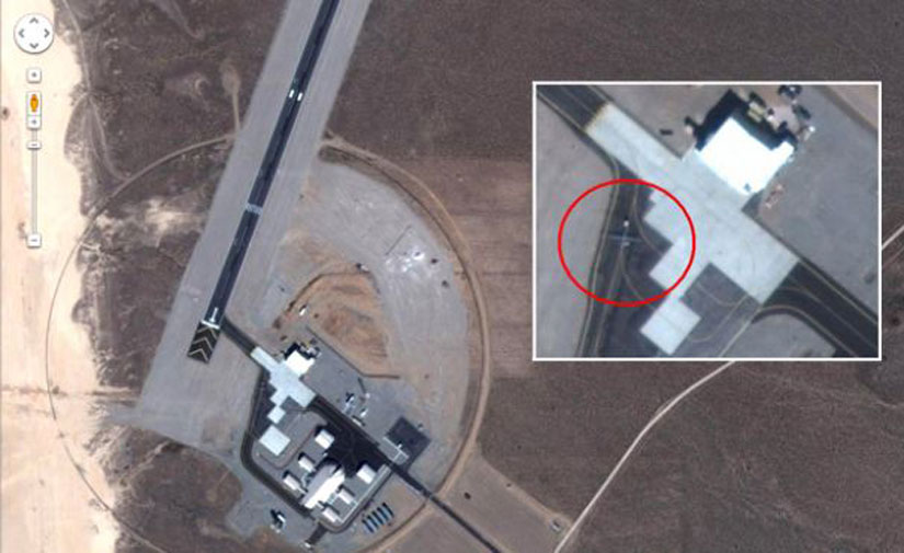
 Today Discovery reported that Google maps may be compromising national security by not censoring secret bases. By using Google maps, anyone can search for famous military bases and zoom in to see the air strips and even secret drones like the RQ-170 Sentinel lost in Iran last week. The Google Maps site shows satellite images of either a Predator or Reaper drone on the airstrip, although Flight Global says the RQ-170 was tested there as well. Such information that is considered top secret is not just a click away.
“Iranians would be most interested in operational bases because that tells them how we fly our surveillance missions,” Leighton told FoxNews.com in an interview. Sure enough, other Nevada military bases at the Tonopah Test Range like the Creech Air Force Base are also viewable at Google Maps. With this information, anyone — even foreign military — can look up satellite images to inspect secret U.S. spy planes.
“Google is making public what was once the sole province of the military and intelligence community, making this a brave new world for the intel agencies as well,” he said. The largely unknown RQ-170 drone from Lockheed Martin made headlines in recent days when it was lost in western Iran. Experts say the drone is the most advanced model yet with high-definition cameras, sensors that can scan for nuclear armaments, and an advanced stealth shell that hides the plane from detection.
On Thursday, a senior U.S. official exclusively confirmed to Fox News that the crashed drone shown on Iranian state television is indeed a fully intact RQ-170 Sentinel increasing the concern about the satellite imagery.
Google has not commented on this story.
via Source.